Right now: 51 for giant trevally, sit it outTap or drag along the water to move through the next 36 hours
Giant trevally, hour by hour
Each float is an hour. The deeper it rides, the better the bite. The strip underneath runs daylight, dusk and dark; the red rule marks the best window. Click any hour to read it.
519 pm
51
51
55Mon
55
51
513 am
51
51
516 am
55
51
519 am
51
51
5512 pm
55
51
513 pm
51
51
556 pm
55
51
519 pm
51
51
48Tue
52
52
483 am
48
48
486 am
48
52
Go, 85+Worth the trip, 70+Marginal, 55+Sit it out
Right now
Water
81°F
Giant trevally range 72–84°
Wind
7 mph
From the east-northeast
Light
Dark
Sunrise 6:32 am
Sky
Partly Cloudy
4% chance of rain
Air
71°F
NWS hourly forecast
Moon
100% lit
Full
What’s biting
Each species is scored against its own water-temperature range and tide preference, then wind, weather and warnings. The rules are Hawaii regulations for these waters.
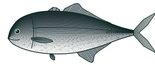
Right in giant trevally's ideal range. Giant trevally prefers incoming tide. Light chop — baitfish active, fish willing to feed. Holds 5–100 ft down.
Keep
10" minimum · 20 a day
Open. Keep fish within the limits. Ulua and pāpio: 10" minimum, 20 a day of all ulua and pāpio species combined (non-commercial); 16" minimum for sale. No closed season.
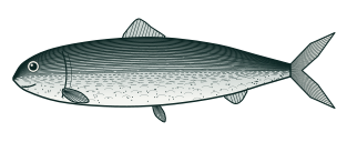
Right in bonefish's ideal range. Bonefish prefers incoming tide. Light chop — baitfish active, fish willing to feed. Holds 1–10 ft down.
Keep
14" minimum · no daily limit
Open. Keep fish within the limits. ʻŌʻio: 14" minimum statewide, no bag limit and no closed season. Marine life conservation districts and fishery management areas have their own rules.
Solunar tables are a popular heuristic. A peer-reviewed test found they don’t predict catch on their own, so here they only nudge the score when the tide or moon already agree. How the score works
Fishing report
No current report covers these waters.
We only show reports an agency has published, with their date. Hawaii DLNR Aquatic Resources has the state’s fishing pages.
Public spots within 40 miles, with the same 36 hours of floats.
9 pm
Mon
3 am
6 am
9 am
12 pm
3 pm
6 pm
9 pm
Tue
3 am
6 am
Waimea Bay Beach Park4 mi · HawaiiBest tonight 12 am–2 amHydrologic Outlook
55Marginal
Mokuleia Beach Park5 mi · HawaiiBest tomorrow 11 am–12 am
80Worth the trip
Sunset Beach7 mi · HawaiiBest tonight 12 am–2 amHydrologic Outlook
55Marginal
Waikiki Beach28 mi · HawaiiBest tonight 12 am–2 amHydrologic Outlook
55Marginal
Questions people ask
Do I need a fishing license to fish at Haleiwa Alii Beach Park?
Yes (anglers age 16 and older). To fish at Haleiwa Alii Beach Park you need the appropriate state fishing license. See the agency's current rules: the state agency website
What fish are commonly targeted at Haleiwa Alii Beach Park?
Haleiwa Alii Beach Park is listed on this site for 2 commonly-targeted species: Giant Trevally, Bonefish. Which species is currently in season and which is scoring highest today is shown in the per-species ranking on this page.
When is the best time to fish at Haleiwa Alii Beach Park?
It depends more on the species and the day's conditions than on a fixed "best hour." Water temperature, weather, and — at tidal locations — the stage of the tide drive activity most. The per-species ranking on this page scores every target species at Haleiwa Alii Beach Park against today's live conditions, so the fish near the top are your best bets right now; check back as conditions change through the day.
What kind of access does Haleiwa Alii Beach Park have?
Haleiwa Alii Beach Park has multiple access types — pier, shoreline, and at least one public boat ramp.
Which state's fishing regulations apply at Haleiwa Alii Beach Park?
state agency regulations apply at Haleiwa Alii Beach Park. Size limits, creel limits, and seasonal closures are listed per species on each species page. Always confirm against the agency source linked from each regulation block — emergency closures can take effect mid-season.
Is Haleiwa Alii Beach Park tidal water?
Yes. Haleiwa Alii Beach Park sits on tidal water with a NOAA tide station nearby. Today's high/low timing is in the tide chart on this page.
Press / anywhere to search. Towns list the closest spots.